Saturday, September 24, 2011

Gringa! Why are you so Dirty? Peru Central Highlands: Caraz – Cusco (25th Aug – 24th Sept '11)

One thing Peru does very well is mountains. After arriving in Caraz and glimpsing the snow-capped peaks of the Cordillera Blanca up behind the town, we started getting up close and personal with a bunch of mountains.

After we spent a few days of rest, bike maintenance and food consumption in Caraz we gave the bikes a rest and our feet a workout – a 4 day hike up into the mountains. We did the popular Santa Cruz trek, wandering past some of the famous mountains of Peru. It was nice to work out some other muscles, other than our riding muscles; though by the time we arrived back at Caraz we were missing the girls and ready to jump back on the bikes and head further up the valley to Huaraz.
 
This section of riding was very social – we met Diana and Zilvinas from Lithuania, we met up again with Jurgen for pizza and beer in Huaraz and then a few days later, we ran into Melissa and Justin, from the States and had a fun couple of days riding with them.
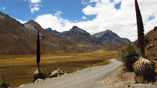
When we left Huaraz we decided to take the “shortcut” through Huarascan National Park – a rough road that climbed up high through the national park but was absolutely spectacular – one of our favourite sections of the whole trip. We had awesome mountain views, beautiful secluded campsites and a lovely couple of days spent poodling up in the high mountains. We were also lucky enough to see the Puja de Raymondii with some old flower stalks on them. These plants have the world's largest inflorescence and they only flower once in their lifetime (and they live between 40 -100 years!). We passed by a number that had old inflorescence on them and the nerdy biologist got disproportionately excited..
The ride up through the national park topped out around 4800 metres, with spectacular views, but an absolutely freezing wind! Once more a serendipitous meeting was a highlight. As we struggled up over the top of one of the passes a motorhome passed us with a German couple, Michelle and Marion inside. They invited us in for coffee and baked goods and shelter from the wind.
We camped up in the park at around 4800 metres, our highest camp so far, and with one of the best views. When we woke in the morning we peeked outside our tent and it was like a winter wonderland – the whole world had turned white! We thought it had snowed in the night, but on closer inspection it could have been a thick layer of ice on everything. We're still not sure what had occurred- we're Australian we don't have much experience in strange white stuff that appears in the middle of the night – but either way everything, tent, bikes was white, and we were pretty excited (tho' Jules was less excited when she realised her morning coffee would be delayed as all our water was frozen solid).
Climbing up that high also meant a great downhill run when we left the national park but as is the case in Peru – going down means going up again. After a couple of days with some great downhills we climbed all the way back up to the altiplano, a plateau of grasslands over 4000m, where we had some nice flat riding and spent time spotting herds of llamas and alpacas, and their wild relatives; the vicunas. We also managed to ride through two hailstorms in this section (and hail damn hurts when you are riding through it on a bike).
Through this section we were generally making our way south, in the direction of Cusco. We didn't have heaps of time to get to Cusco, as we had to meet my Mum and her best friend, Lacey, who were coming out to visit. And during this time we had to cycle 1700 kms, cross eight passes over 4000m and cycle through the infamous “Peruvian rollercoaster” a section of gravel road that goes up and down from low to high altitude like a heart monitor chart.
We rested up in Ayacucho, a very pretty colonial town with a great selection of markets and street-food, before the final push to Cusco.
The road from Ayacucho was supposedly the worst stretch of the road but it was not actually as bad as we expected. They are currently doing the road up, which meant some bad stretches of roadworks but also meant that there were sections that had been improved, providing us with random stretches of asphalt allowing us to zoom down some of the 50km+ downhills. It was some really interesting riding, camping up above 4000m in the freezing cold, but beautiful, high-altitude grasslands and then going all the way down to under 2000m where it was hot, the sandflys attacked us but where we hit areas of delicious tropical fruits and could stuff ourselves with mangoes.
We passed through lots of friendly little villages where the little old lady shop-proprietors hugged you before you were allowed to conduct any business dealings, and we camped amongst lots of friendly, and fascinated locals. The cry of 'gringo' followed us everywhere, though it was always friendly – except perhaps one shocked little old lady who was horrified about the layer of dirt and dust covering me, and called out “Gringo – why are you so dirty?”
The last few days of cycling before Cusco was again very social. Since the west coast of the US we have not met many other cycle tourists, so its nice to start meeting cyclists travelling South America. We cycled and camped with a number of other couples and on our last night before Cusco there were 7 of us that found a dry, warm floor in the government buildings of a small town. A cyclists sleepover. Even more exciting was arriving in Cusco and meeting old cycling friends, the Dutch boys - Michiel and Joost, Siska, the Lithuanians and the French couple were all there.
There was also our Australian motorcycling friends, some overlanders and the cyclists we met over the last few days. Most of us ended up at the cyclist friendly hostel, La Estrellita, and all of us ended up at the pub. This resulted in a few large gatherings , and of course, being cyclists, lots of eating. One night we had 20 cyclists and 4 overlanders that did some serious damage on an Indian buffet and then (for some of us) some serious damage on the dancefloors of Cusco.
We are now putting the bikes away for a few weeks – leaving them in Cusco while we go to meet mum and Lacey for some bikeless tourist-time.
Notes for Cyclists
We took the fairly standard mountain route from Huaraz (as evidenced by the number of cyclists we met). Info on the route is available here: http://panamriders.biketravellers.com/peru-mountain-routes/
We did take the shortcut through Huascaran National Park after Huaraz – about 42km south of Huaraz turn off onto an unsigned dirt road at the deserted town (a few houses) of Pachacoto (there is a board with a map of the national park a little way up the road). At the border post of Carpa you enter the park (we used our 'Adventure Ticket' that we had bought when we did the Santa Cruz trek so we didnt' have to pay the entrance again).
We also took the 'canyon' route from Izcuchaca to Ayacucho, instead of the 'mountain' route through Huancavelica. It was mainly gravel (except for about 50kms before Ayacucho) and it was hot and full of horrible sandflys! But we still enjoyed it – lots of great, friendly little villages. It took us about 3 days.
The road between Ayacuho and Abancay they are starting to make into asphalt, so there are suprising stretches of pavement along the way – but also some tough sections through roadworks!! It will all be asphalt in a few years. Still nice and quiet with not too much traffic for now tho!

Thursday, September 1, 2011

The Back Door Into Northern Peru: Vilcabamba, Ecuador – Caraz, Peru (2nd - 24th August '11)

At the end of our stay in Ecuador we took the dirt road south from Vilcabamba to the border of Peru. We left behind the asphalt not long after Vilcabamba and our last few days in Ecuador were on steep (up to 16 %) gravel slopes, up and down the mountains. It was some very enjoyable riding though – we had joined up with Jurgen, our German friend we first met cycling in the Yukon (more than a year ago!) and our days were filled with cycle gossip (its amazing how much we actually have to gossip about), made-up games (though we quickly discovered that eye-spy in Spanish is not that much of a challenge when our vocabulary is so limited!) and finding great places to camp.
We managed to camp outside churches, abandoned schools, volleyball courts and inside a municipal building that the people in town smashed a window to get into – we were a little concerned that we were breaking into the government offices but the town assured us that it was no problem, they had simply locked the keys inside.
 These last days in Ecuador we met lots of friendly people – including a large family of children who were absolutely thrilled when we camped next to their house. We played volleyball and soccer with them, they “helped” us put up our tents and cook our dinner and when we woke in the morning they were all sitting patiently in front of our tent waiting for us to provide their morning's entertainment.
We crossed into Peru just south of Zumba, at Chonta/La Balsa, the most chilled border crossing I have done – we had to tear our immigration officer away from his karaoke machine to fill out our paperwork. After we had passed over the bridge and entered Peru we found that the Peruvian road engineers are a little more considerate to poor cyclists - the gravel was a little less bone-shaking and the road gradients were a lot kinder – though it did mean that the climbs were suddenly a lot longer... ups and downs of more than 50kms is quite normal in Peru!
Arriving in Peru we slowly dropped in altitude, the landscape started to get more lush and green and the weather grew more sultry, until on our third day in Peru we were in the “Amazonia” area, sweltering in the heat and riding along a flat road through a valley of irrigated rice paddies and palm-trees. The road also turned to asphalt and after the super-steep rocky climbs that we had come through we could enjoy the ease of smooth cycling. We hadn't experienced 'flat' for a long time and it was a nice change for a couple of days.. though of course it couldnt' last too long, and after a few days we left the main road at Pedro Ruiz to head west on a dirt road through a very pretty parrot-filled canyon along the Rio Utcubamba– slowly climbing our way back up into the mountains.
On the way from the Amazonia up into the northern mountains we passed by Kuelap, an old Chachapoyan ruin, that was worth a day off to do a 3-hour hike from the town of Tingo up to the site's impressive perch overlooking the surrounding mountains. In Tingo we also met an English/Polish couple cycling north to south, and we could happily pick their brain about the next part of our route. We didn't have that much info on the back roads that we were going to take in the next week or so as we didn't know many cyclists that had done this route but Sywlia and Matthew had just come from there... they left us with the less than satisfying information that we were headed for “the hardest roads that they had done in Peru” and that one of our next downhill sections (60km long) was worse than 'The Worlds Most Dangerous Road' – sandy, narrow and with steep dop-offs on the side. Hmmm reassuring.
However, while the roads deteriorated as we headed back into the mountains the scenery certainly proved diverse. As we passed through the mountains we would go from green dairy farming areas in the mountainous areas all the way down to arid desert landscapes in the canyons. One chilly mountain night we warmed ourselves by a fire with a friendly campesino family (who insisted that we camp in their potato barn as our tent would be too cold) and the next night we were camped down in the desert with the fly open, watching the stars above us in the warm, dry air. Winding our way through these mountains meant some impressive ascents and descents – one memorable progression was a 30km climb, followed by a 60km descent and then straight back up into a 45km climb!
After all this climbing we were looking forward to some time off in Cajamarca, a nice laidback colonial town, where we spent our time eating our way through the streets and markets. We had heard lots of great things about the food of Peru but up until Cajamarca we had struggled to even find much to eat in the small towns that we had passed through. In these towns it was difficult to determine which houses were also shops and we had spent a lot of time peering into darkened doorways to see if they had any food for sale. Cajamarca was heaven though, we discovered a glorious array of streetfood, fried goodness and enough sweet things to load our bodies up with sugar for the next part of the rough roads through the mountains ahead. Our other present to our bodies after all their hardwork through the mountains was calling in at the hotsprings of Banos del Inca to have a wallow in the blissfully warm waters.
We tore ourselves away from the hot springs and fried things of Cajamarca and headed off again through the mountains, generally south, winding our way through some smaller roads and tracks to try and connect up with Huaraz and the Cordillera Blanca. This involved about a week of climbing up and down mountains. As we got further south the roads deteriorated until we were on some tough sandy/rocky roads that switchbacked up and down mountainslopes, from farming areas and small villages up high, down to arid and desert landscape in the bottom of the valleys. We passed through small villages and met some lovely Peruvians, including a couple of cyclists (Alex and Eduardo) who rode and chatted with us for a while and an Evangelical pastor who invited us in for lunch and then blessed us and our journey – which must have worked as we ended up with a big long stretch of nice, easy riding on bitumen that we weren't expecting!
Tired legs from climbing, cramped hands from braking on the long downhills and completely covered in dust from camping in the desert we were happy when we reached a flat section of road through a canyon along a river. Pretty landscape and fairly good roads -including 30kms of bitumen! However, after a too-short period we were out of the canyon and back on bone-shuddering gravel roads, and a gentle climb up through the desert and into the Canyon del Pato with its multiple tunnels (where we had to strap on lights and head into the darkness, hoping for no cars as we attempted to ride in pitchblack, on rough roads). Eventually we popped out into the Calleyon de Huaylas, a pretty valley that runs alongside the beautiful Cordillera Blanca with its impressive snowy peaks hovering in the background. We were pretty worn-out from lots of rough roads and mountain riding and we were filthy from head to toe. Our poor bikes hadn't faired much better during our last few weeks of riding. Norma and Betty had bolts shaken loose, racks broken and were making lots of strange noises. We were very ready for a good rest and clean-up in the chilled little town of Caraz.
While the back roads through Northern Peru were not alwasy easy, all the hard work of the last few weeks was definitely worth it - passing through a creased landscape of mountains and rivers, deserts and forests with great views, quiet roads, little villages.. what more could you ask for!

 
Notes for Cyclists (warning – the distances I include are always pretty rough!)
From Vilcabamba, Ecuador to Cajamarca, Peru
Steep, rough roads from just south of Vilcabamba (though they are currently paving some sections of the road just south of V!) to around 55km after San Ignacio in Peru. After Tamporapa we took the shortcut to Bagua Grande by crossing the Rio Maranon (and avoiding Jaen). Take the small gravel road turnoff to Bellavista (signposted), travel 12km to the river, then cross with the boatmen (1.5 soles pp), another 8ish kms over mainly gravel until you meet back up with the main road.
After Bagua Grande we turned off the main road at Pedro Ruiz to head towards Chachapoyas and then Cajamarca. After the turn-off it is back to dirt roads until Encanada, about 35kms(?) before Cajamarca ...
From Pedro Ruiz to Leimebamba you do some very gradual climbing – we hardly noticed that we were ascending. After Leimebamba there is a 30km ascent, then a 60km descent to Balsas, then a 45km climb up to the pass, then another 10km down to Celendin. The first 50kms out of Celendin is generally climbing, then lots of descending over the next 60ish kms to Cajamarca.
From Cajamarca to Caraz
The first section from Cajamarca until we turned off the main road is all asphalt (supposedly the whole road from Cajamarca to Trujillo has recently been asphalted).
We took the shortcut from just after Huamachuco across to Angasmarca – its a little hard to find. Some people we asked told us that it didn't exist (including the Carretera Policia!) and the only real directions we had was that we had to turnoff the main road before the big bridge over the river. The turnoff was about 8-9kms after leaving Huamachuco – a small gravel road up to the left out of a little village. Its easy to miss (there was a bus parked in front of it and we missed it and got down to the bridge -Puerte Yambabomba or something and had to ride back up the 500m or so). Just ask lots of (different) people for directions – you can ask for the road to Angasmarca, or the road to San Simeon (which is the mine part way along).
Its a dirt road but quite enjoyable through the grasslands. There are quite a few small tracks along the way – we just kept asking the locals the way, and I think most of the roads end up in Angasmarca. About 15kms in you skirt through the bottom of the mine and then climb up and around a summit. When you get to the cemetery (about 20ishkms off the main road) there are two forks. At the first one go left, at the second one (only a few metres past the cemetery) you have a choice – the track to the left is the 'main' track to Angasmarca that the trucks and collectivos go on. We got told by a few people that the track to the right was shorter so we took that one – but I'm not sure which is better! The track to the right was quite rough with lots of loose rocks; however, it was flatish for a while and then we had a big downhill, then the track improved tho' it climbed up and down again to the town of Cachicadon. You then take the track out of town up over a hill and then down to Angasmarca. It was about 46km from the turnoff of the main road out of Huamochuco to Cachicadon and then about another 27km to Angasmarca. From Angasmarca you head to Mollepata (about 30km) on some tough roads – a couple of steep sandy sections, and a bit of ascending and descending. From Mollepata there is a 10km drop down to the river, then a 20ish km climb up to Pallasca, then another 22ish km drop back to the river (this road was in pretty bad condition – they were doing roadworks on it which had made it even worse than what it was!), then ~62km alongside the river, through the canyon, which is all gradually downhill, on roads in much better condition, and the last 25kms are asphalt. Just before the small 'outpost' of Chiquicara, we turned off the road onto the gravel road heading east through the Canyon del Pato and onto Caraz, Huaraz etc. After Chiquicara it is about 93km of really bad dirt road, some washboard, lots of rocks, gradually climbing (tho' often with a tailwind). This section includes the Canyon del Pato, and there are lots of tunnels – some short but some long, and very dark! Then the last 25kms (after you leave the Canyon del Pato to Caraz) is asphalt.